
The Building Footprint dataset, produced by Google Research under the Open Buildings project, is a large-scale open-access dataset containing the outlines of 1.8 billion buildings across Africa, Asia, Latin America, and the Caribbean. Launched in 2021, the project covers about 40% of the globe and 54% of the world’s population. The dataset was developed as a solution to the challenge of obtaining detailed building footprint data in the Global South, where high-resolution satellite imagery is often scarce.
Who Produced the Data
This dataset is a result of efforts from Google’s AI Research Lab in Accra, Ghana. Google Research led the project with support from various global teams. The project aimed to support population estimation, urban planning, and various social and environmental initiatives, especially in areas where such data was previously unavailable.
When the Data Was Produced
The project began in 2021, but it has undergone continuous refinement. As of the latest updates, the dataset covers key regions of the Global South and remains open for access to anyone interested in using it. This ongoing evolution reflects Google’s efforts to address the unique challenges presented by regions with low-quality satellite imagery or where manual data collection is difficult.
How the Data Was Produced
The dataset was produced using AI to super-resolve and extract building footprints from publicly available low-resolution Sentinel-2 satellite imagery. AI models were specifically trained to work with these lower-resolution images, as high-resolution satellite imagery is often unavailable in many parts of the Global South. Although the resolution of the input data limits the dataset’s precision, Google’s models can identify building presence and geometry with a relatively high degree of accuracy. The data includes a confidence score for each pixel, which helps users understand the reliability of the data for each building.
Accuracy and Limitations
While the Open Buildings dataset provides significant insights, there are limitations to the accuracy of the data:
- Cloud Cover: Clear skies are necessary to capture accurate imagery, but in areas with frequent cloud cover, data reliability can decrease.
- Tiny Structures: Very small buildings, such as informal shelters, can be missed due to the resolution limitations of the satellite imagery.
- Pixel vs. Polygon: Unlike earlier datasets that could produce detailed building polygons, this dataset uses pixel data to indicate building presence due to the lower-resolution input.
- False Positives and Stitching Errors: The dataset can include errors due to image stitching problems or misclassifications.
Despite these limitations, the dataset has seen significant improvements, particularly in complex environments like dense urban areas and rural settlements.
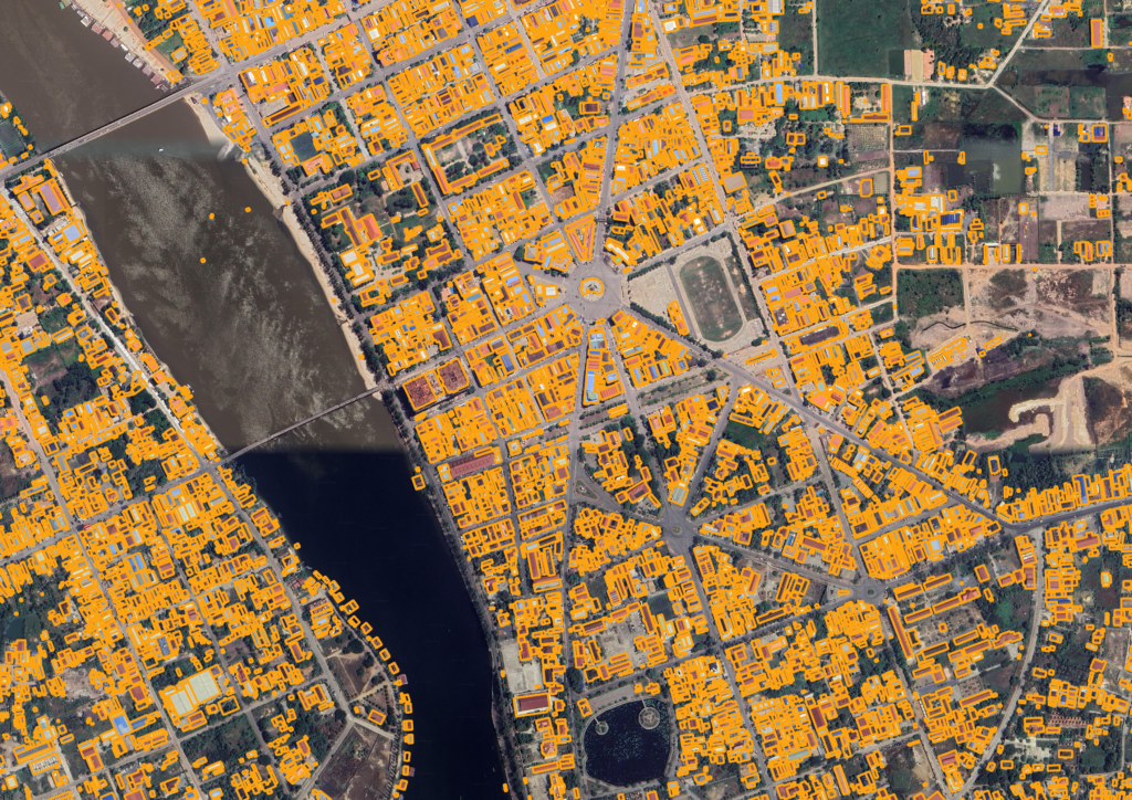
Use Cases for Developing Nations - Cambodia
The Open Buildings dataset is especially beneficial for developing nations, where it provides crucial information in regions where there is little to no infrastructure for manual data collection. Its use cases include:
- Population Mapping: It helps in estimating population density, particularly in areas undergoing rapid change or where census data is outdated.
- Humanitarian Response: In disaster-affected areas, the data aids in assessing the number of buildings impacted and the required response.
- Environmental Science: Understanding settlement density allows for better energy need estimations and environmental impact analysis.
- Urban Planning: The data can support planning in rapidly growing urban areas or informal settlements.
- Addressing Systems: In regions without formal address systems, the data can be used to create digital addresses, improving access to services and economic opportunities.
- Healthcare and Vaccination Planning: By estimating population distribution, this data can help governments plan vaccine distribution, anticipate healthcare demand, and enhance epidemiological efforts.
This dataset is a powerful tool for governments, NGOs, and researchers focused on developing nations. It addresses significant data gaps, offering a way to understand and address key challenges in infrastructure, health, and environmental management.
Download Here
I have prepared the Building Footprint Data of Cambodia, divided into 25 sections, representing the 25 provinces and cities of Cambodia. You can download the data using the button below, which links to my OneDrive. I hope this contribution helps accelerate your project and makes a positive impact on the development of Cambodia.
References
Open buildings – Google Research. (n.d.). Open Buildings. https://sites.research.google/gr/open-buildings/
Graham, O. (2024, September 19). Open Buildings: AI-powered maps for a changing world. Google. https://blog.google/technology/research/open-buildings-ai-powered-maps-for-a-changing-world/
Annkah, A. (2022, October 11). How mapping the world’s buildings makes a difference. Google. https://blog.google/around-the-globe/google-africa/how-mapping-the-worlds-buildings-makes-a-difference/
Sirko, W., Kashubin, S., Ritter, M., Annkah, A., Bouchareb, Y. S. E., Dauphin, Y., Keysers, D., Neumann, M., Cisse, M., & Quinn, J. (2021, July 26). Continental-Scale Building Detection from High Resolution Satellite Imagery. arXiv.org. https://arxiv.org/abs/2107.12283